My Favorites


Loading..


This area does not yet contain any content.
Hire Me!
Hire Me! Hire me for your writing assignment or event. I'm reasonable and reliable. Also looking for additional writing gigs. Email me at rclimpert003@yahoo.com

Based in Atlanta, GA - Rick Limpert is an award-winning writer, a best-selling author, and a featured sports travel writer.

Named the No. 1 Sports Technology writer in the U.S. on Oct 1, 2014.

Entries in Gulf (5)

Thursday
Aug302012

Dramatic Video of Isaac Hitting the Gulf

Newly downgraded Tropical Storm Isaac plodded its way across Louisiana on Wednesday, inundating parts of a mostly rural area southeast of New Orleans. In hard-hit Plaquemines Parish, officials rescued dozens of people by boat after they became stranded by floodwaters.

Wednesday
Aug292012

Isaac Pounds Gulf Coast

Isaac stalled over southeastern Louisiana on Wednesday morning, dumping torrential rains across the Gulf Coast and pounding low-lying areas with 8- to 10-foot storm surges and 75-mph winds. The National Hurricane Center warned that hurricane conditions would persist all day and into the evening for storm-battered coastal residents.

The huge, slow-moving storm knocked down trees and power lines, flooded roads and highways and sent bands of wind and rain pelting an area from New Orleans to the Florida panhandle. Isaac, a Category 1 hurricane, is expected to be downgraded to a tropical storm late Wednesday as it slowly crawls north toward Arkansas and the Mississippi River Valley.

Monday
Jun252012

The Aftermath of Debby

Lots of rain, flooding and tornadic activity.

This is what Debby brought to various places on the Gulf Coast of Florida.

The surge was very strong, sunk a number of boats, destroyed many docks, flooded entire bays along some parts of the Gulf.

Saturday
Jun232012

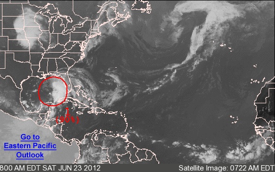
Low Pressure Area Could Become Tropical Storm Debby

From the National Hurricane Center:

FOR THE NORTH ATLANTIC...CARIBBEAN SEA AND THE GULF OF MEXICO...

1. THE CENTER OF CIRCULATION OF THE BROAD AREA OF LOW PRESSURE OVER THE
GULF OF MEXICO APPEARS TO BE BECOMING BETTER DEFINED ABOUT 275
MILES SOUTH-SOUTHEAST OF THE MOUTH OF THE MISSISSIPPI RIVER.  IN
ADDITION...SHOWERS AND THUNDERSTORMS HAVE BEEN INCREASING OVER THE
EASTERN GULF OF MEXICO...AND A NOAA BUOY LOCATED ABOUT 130 MILES
EAST-NORTHEAST OF THE CENTER HAS PRODUCED TROPICAL-STORM-FORCE
WINDS WITHIN THE PAST COUPLE OF HOURS.  A TROPICAL DEPRESSION...OR
MORE LIKELY A TROPICAL STORM...COULD FORM LATER TODAY OR TONIGHT IF
THE DEVELOPMENT TREND CONTINUES.  THIS SYSTEM HAS A HIGH CHANCE...
90 PERCENT...OF BECOMING A TROPICAL CYCLONE AS IT MOVES SLOWLY
NORTHWARD DURING THE NEXT 48 HOURS.  

TROPICAL STORM WATCHES OR WARNINGS COULD BE REQUIRED FOR A PORTION
OF THE NORTHERN GULF COAST OVER THE WEEKEND...AND INTERESTS IN THIS
AREA SHOULD CONTINUE TO MONITOR THE PROGRESS OF THIS LOW.  HEAVY
RAINS AND LOCALIZED FLOODING ARE POSSIBLE ACROSS THE YUCATAN
PENINSULA...WESTERN CUBA...AND MUCH OF FLORIDA OVER THE NEXT DAY OR
SO.  AN AIR FORCE RESERVE RECONNAISSANCE AIRCRAFT IS SCHEDULED TO
INVESTIGATE THE SYSTEM THIS AFTERNOON.

ELSEWHERE...TROPICAL CYCLONE FORMATION IS NOT EXPECTED DURING THE
NEXT 48 HOURS.
Friday
Sep022011

Tropical Storm Could Impact Gulf

The National Weather Service issued a tropical-storm warning Thursday evening that extends across the Mississippi, Louisiana and Texas coastlines.

On its current track, NWS meteorologist Bob Wagner said, Tropical Storm Lee is expected to make landfall Saturday afternoon or evening in southwest Louisiana with winds up to 60 miles per hour. Landfall at that location would bring winds of up to 40 miles per hour to the Mississippi Coast. The tropical depression was not expected to become a hurricane. It was interacting with an upper-level low-pressure system to produce large areas of showers and thunderstorms.

The tropical-storm warning was issued after the Hurricane Hunters flew into the Gulf storm Wednesday afternoon.

Wind speeds were measured at 35 miles per hour.