My Favorites


Loading..


This area does not yet contain any content.
Hire Me!
Hire Me! Hire me for your writing assignment or event. I'm reasonable and reliable. Also looking for additional writing gigs. Email me at rclimpert003@yahoo.com

Based in Atlanta, GA - Rick Limpert is an award-winning writer, a best-selling author, and a featured sports travel writer.

Named the No. 1 Sports Technology writer in the U.S. on Oct 1, 2014.

Entries in Hurrican (7)

Saturday
Jun232012

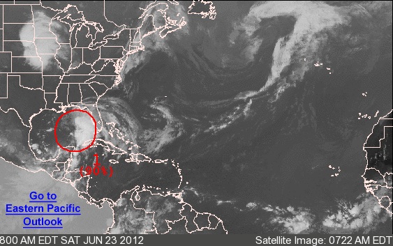
Low Pressure Area Could Become Tropical Storm Debby

From the National Hurricane Center:

FOR THE NORTH ATLANTIC...CARIBBEAN SEA AND THE GULF OF MEXICO...

1. THE CENTER OF CIRCULATION OF THE BROAD AREA OF LOW PRESSURE OVER THE
GULF OF MEXICO APPEARS TO BE BECOMING BETTER DEFINED ABOUT 275
MILES SOUTH-SOUTHEAST OF THE MOUTH OF THE MISSISSIPPI RIVER.  IN
ADDITION...SHOWERS AND THUNDERSTORMS HAVE BEEN INCREASING OVER THE
EASTERN GULF OF MEXICO...AND A NOAA BUOY LOCATED ABOUT 130 MILES
EAST-NORTHEAST OF THE CENTER HAS PRODUCED TROPICAL-STORM-FORCE
WINDS WITHIN THE PAST COUPLE OF HOURS.  A TROPICAL DEPRESSION...OR
MORE LIKELY A TROPICAL STORM...COULD FORM LATER TODAY OR TONIGHT IF
THE DEVELOPMENT TREND CONTINUES.  THIS SYSTEM HAS A HIGH CHANCE...
90 PERCENT...OF BECOMING A TROPICAL CYCLONE AS IT MOVES SLOWLY
NORTHWARD DURING THE NEXT 48 HOURS.  

TROPICAL STORM WATCHES OR WARNINGS COULD BE REQUIRED FOR A PORTION
OF THE NORTHERN GULF COAST OVER THE WEEKEND...AND INTERESTS IN THIS
AREA SHOULD CONTINUE TO MONITOR THE PROGRESS OF THIS LOW.  HEAVY
RAINS AND LOCALIZED FLOODING ARE POSSIBLE ACROSS THE YUCATAN
PENINSULA...WESTERN CUBA...AND MUCH OF FLORIDA OVER THE NEXT DAY OR
SO.  AN AIR FORCE RESERVE RECONNAISSANCE AIRCRAFT IS SCHEDULED TO
INVESTIGATE THE SYSTEM THIS AFTERNOON.

ELSEWHERE...TROPICAL CYCLONE FORMATION IS NOT EXPECTED DURING THE
NEXT 48 HOURS.
Wednesday
Oct262011

Rina Strengthens, Closes in on Mexico

Rina is moving towards Mexico and precautions are being taken.

"Rina has the potential to become a major hurricane today or tonight," the U.S. National Hurricane Center said.
Rina is a Category Two hurricane on the Saffir-Simpson intensity scale, packing winds of 110 mph. When sustained winds hit 111 miles per hour storms are considered major Category Three hurricanes.

The sixth hurricane in the Atlantic season this year, Rina was located 215 miles east southeast of Chetumal, Mexico, and 235 miles south southeast of Cozumel early on Wednesday, and was moving west at 5 mph.

The storm was expected to be near or over the east coast of the Yucatan peninsula late Wednesday and on Thursday.

Some cruise ships revised their travel schedules and the governor of Quintana Roo ordered hundreds of people evacuate the fishing village of Punta Allen on the Yucatan peninsula's western coast on Tuesday.

Thursday
Sep012011

Forecasters Watching Tropical Storm Katia

Tropical Storm Katia, moving west- northwest across the Atlantic Ocean, is likely to strengthen into a hurricane soon, according to the U.S. National Hurricane Center.

Katia, 1,285 miles east of the Leeward Islands in the Caribbean, had maximum winds near 70 mph, up from 65 mph earlier today, the NHC said in an advisory at about 4:40 p.m. East Coast time. The storm, which will become a hurricane when its winds reach 74 mph, is traveling at 20 mph on a path that will take it to waters northeast of Puerto Rico on Sept. 4, the Miami-based center said.

“Katia could become a major hurricane by the upcoming weekend as it passes north of the Lesser Antilles,” said Brian Edwards, a meteorologist for private forecaster AccuWeather in State College, PA.

Katia is the 11th named storm of this Atlantic Hurrican Season, which runs from June 1 to Nov. 30. The NHC says the average hurricane season usually produces that many in total.

Thursday
Aug042011

Tropical Storm Emily Video Update

The tropical storm is regaining strength as it changes course.

Tuesday
Aug022011

Tropical Storm Emily Heading to Florida

Tropical storm Emily has been strengthening as it moves on its northwestern path and pushes its way through the Caribbean.

Earlier this morning, Emily was about 265 miles off the coast of Puerto Rico traveling around 17 miles an hour but it is expected to speed up as it moves across the Caribbean Sea today and moves closer towards the Dominican Republic, where there is a tropical storm watch.

By evening, it is projected that Emily will make its way to the island of Hispaniola.

In the latest advisory by the US National Hurricane Centre, Haiti, the US Virgin Islands, and the islands of St. Kitts, Nevis, Montserrat, and Antigua were also under a tropical storm watch.

Emily has yet to be defined as a Category 1 hurricane, the weakest type of hurricane where damage is typically leads to broken windows, destruction of older homes and roofs.

Thus far, Emily's maximum winds were up to 40 miles per hour. They should get stronger.