Wednesday
Oct312012
Surveying Sandy Damage
Day 2 after Sandy. What are the damage estimates?
Based in Atlanta, GA - Rick Limpert is an award-winning writer, a best-selling author, and a featured sports travel writer.
Named the No. 1 Sports Technology writer in the U.S. on Oct 1, 2014.
Day 2 after Sandy. What are the damage estimates?
CNN is really covering Sandy from wall to wall.
They even got a survivor of the storm made famous in the movie, The Perfect Storm to give his expert opinion.
http://www.cnn.com/2012/10/29/us/sandy-bounty-ship/index.html
 Events, News, People, Travel, Weather
 Sandy is forcing many to make some tough decisions.
Mayor Bloomberg is urging an evacuation of parts of New York.
Here is a good article and a video.
http://www.usatoday.com/story/news/nation/2012/10/28/new-york-sandy-transit/1663663/
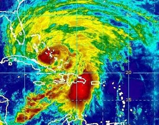
The National Weather Service in Melbourne, Florida has issued tropical storm warning for all of the coastal counties in east Central Florida, including Florida's Space Coast.
There are now also various watches and warnings all the way up the East Coast of the U.S. to Maine.
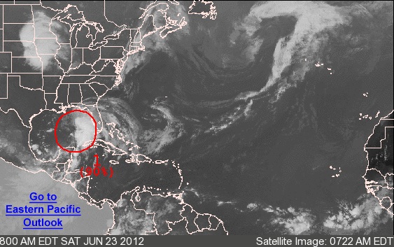
From the National Hurricane Center:
FOR THE NORTH ATLANTIC...CARIBBEAN SEA AND THE GULF OF MEXICO...

1. THE CENTER OF CIRCULATION OF THE BROAD AREA OF LOW PRESSURE OVER THE
GULF OF MEXICO APPEARS TO BE BECOMING BETTER DEFINED ABOUT 275
MILES SOUTH-SOUTHEAST OF THE MOUTH OF THE MISSISSIPPI RIVER.  IN
ADDITION...SHOWERS AND THUNDERSTORMS HAVE BEEN INCREASING OVER THE
EASTERN GULF OF MEXICO...AND A NOAA BUOY LOCATED ABOUT 130 MILES
EAST-NORTHEAST OF THE CENTER HAS PRODUCED TROPICAL-STORM-FORCE
WINDS WITHIN THE PAST COUPLE OF HOURS.  A TROPICAL DEPRESSION...OR
MORE LIKELY A TROPICAL STORM...COULD FORM LATER TODAY OR TONIGHT IF
THE DEVELOPMENT TREND CONTINUES.  THIS SYSTEM HAS A HIGH CHANCE...
90 PERCENT...OF BECOMING A TROPICAL CYCLONE AS IT MOVES SLOWLY
NORTHWARD DURING THE NEXT 48 HOURS.

TROPICAL STORM WATCHES OR WARNINGS COULD BE REQUIRED FOR A PORTION
OF THE NORTHERN GULF COAST OVER THE WEEKEND...AND INTERESTS IN THIS
AREA SHOULD CONTINUE TO MONITOR THE PROGRESS OF THIS LOW.  HEAVY
RAINS AND LOCALIZED FLOODING ARE POSSIBLE ACROSS THE YUCATAN
PENINSULA...WESTERN CUBA...AND MUCH OF FLORIDA OVER THE NEXT DAY OR
SO.  AN AIR FORCE RESERVE RECONNAISSANCE AIRCRAFT IS SCHEDULED TO
INVESTIGATE THE SYSTEM THIS AFTERNOON.

ELSEWHERE...TROPICAL CYCLONE FORMATION IS NOT EXPECTED DURING THE
NEXT 48 HOURS.

