My Favorites


This area does not yet contain any content.
Hire Me!
Hire Me! Hire me for your writing assignment or event. I'm reasonable and reliable. Also looking for additional writing gigs. Email me at rclimpert003@yahoo.com

Based in Atlanta, GA - Rick Limpert is an award-winning writer, a best-selling author, and a featured sports travel writer.

Named the No. 1 Sports Technology writer in the U.S. on Oct 1, 2014.

Entries in snow (40)

Tuesday
Nov222011

Winter Weather Hits Rockies Leading Up to Thanksgiving

Snow showers are moving over the Rocky Mountain Front will make for hazardous travel at times through Wednesday morning.

A Winter Weather Advisory is now in effect for the northern Rocky Mountain Front until 11 a.m. Wednesday.

The strong winds will produce areas of blowing snow and could reduce visibilities below 1/4 of a mile at times.

This advisory affects numerous passes in the Rockies.

6-12 inches of snow are expected over the mountainous areas of this region.

3-6" could fall at the lower elevations through Wednesday.

Thursday
Nov102011

Snow and Winds Hit Alaska

With hurricane-force winds, an Alaskan storm of "epic proportions" hit the coastal communities, sending some residents fleeing to higher ground as it tore roofs from homes and knocked out power.

The strongest storm to hit the state in four decades sent water levels rising late Wednesday night in Nome, with flooding reported in low-lying areas, the National Weather Service said.

"It's barely beginning to wind down along the coast," Stephen Kearney, a meteorologist for the Weather Service in Fairbanks, said late Wednesday night.

Emergency officials warned that areas on Alaska's western coast between Norton Sound and Point Hope were vulnerable to a possible surge of sea water that could bring varying degrees of flooding to villages already soaked.

However, there were no new reports of substantial damage in Nome late Wednesday night, the National Weather Service said.

Flooding was reported in Point Hope, where the water came within 10 feet of the airport runway, but the community still had power, Kearney said.

Earlier, the storm produced 85-mph gusts, well above hurricane force. But emergency managers said that the winds had begun to taper off and were clocked with still-potent gusts of 55 mph. The storm passed through more southern points of its path.

Some villages, such as Kivalina, could be even more vulnerable with winds shifting as they head to Russia, officials said.

Water reportedly reached some reached homes in at least four Native villages, including Tununak and Kipnuk, state emergency managers said earlier Wednesday.

"This is a storm of epic proportions," said meteorologist Jeff Osiensky with the National Weather Service. "We're not out of the woods with this."

The last time the communities saw something similar was in November 1974, when a storm created a sea surge that measured more than 13 feet. The surge pushed beach driftwood above the level of the previous storm of its type in 1913.

Friday
Feb042011

A Snowy Super Bowl in Dallas


This isn't Green Bay or Pittsburgh, PA. This is North Texas, and North Texas is a mess.

Snow on the ground. Rotating power outages. Drivers sliding around on slush and ice. Low gas pressure. Temperatures in the teens.

The entire region experienced the planned power outages Wednesday as officials tried to maintain the integrity of the state’s power grid during the extreme cold weather that is gripping much of Texas.

The state’s major grid operator, the Electric Reliability Council of Texas (ERCOT), and major power generators worked feverishly to restore generating units to full service and at about 2 p.m. ERCOT issued a statement saying the blackouts were no longer needed Wednesday afternoon.

The statement said, however, that there was a strong possibility that blackouts could return Wednesday night and throughout the week.

I would have to say the people least affected by the weather problems in Dallas have to be the teams themselves. Everything they do is so controlled, they can just go about their business.


Monday
Jan312011

Midwest Expecting Lots of Snow

If you are in the Midwestern part of the United States, you are currently experiencing the calm before the storm.  Heavy snow is expected throughout the Midwest this week.  And it will keep coming and coming.

The first of the snow is expected to arrive afternoon in the way of about a half an inch, according to the National Weather Service. Today’s high will be 25 degrees.

The snow is expected to continue tonight with overnight accumulations of 2 inches.

More snow is expected Tuesday with accumulation of around 4 inches.

Then the bulk of the storm will hit with about 9 inches of accumulation expected Tuesday night and into Wednesday morning. We could see snow accumulation rates of 2 inches an hour. On top of the snow, expect some areas of blowing snow with  wind chill values as low as -10 degrees. A winter storm watch will be in effect from Tuesday afternoon through Wednesday afternoon.

Blowing and drifting snow is expected on Wednesday. Then the temperatures plunge with Wednesday night low will be -9 degrees .


Monday
Jan242011

More Cold and Snow All Over

The severely cold weather will set the stage for "a potent winter storm" early this week, forecasters for the Weather Channel said.

AccuWeather.com's Alex Sosnowski predicted the Northeast is in for a storm rivaling last month's Christmas blizzard.

"More and more signs are pointing toward a major storm along much of the Atlantic Seaboard ... meaning a wind-whipped snow for some areas and wind-driven rain for others," he said on AccuWeather's website.

The snowy shellacking isn't expected to arrive until Monday night after the Southeast gets its own cold soak, the Weather Channel said.

"After a dry day region-wide on Monday, snow will begin to move in from the Midwest Monday night into Tuesday, with a stronger and messier system moving up the coast on Wednesday," Weather Channel meteorologist Mark Avery said.

Upstate New York and New England were forecast to dip into the single digits.

Meteorologist Daniel Brown of Springfield, Massachusetts, news channel abc40 said temperatures there could sink to a new record low of minus 20 degrees on Monday morning, beating the current record nadir of 12 below zero set in 1961.

"The bitter blast will loosen its grip by Tuesday afternoon," Brown stated.

Tennessee Department of Transportation chief engineer Paul Degges wrote on the agency's website that TDOT is working to replenish its salt supplies. In the meantime, the state will increase its use of snow plows, and step up the use of salt brine and calcium chloride to stretch its de-icing capacity.

Snow had already begun to coat Midwest and Plains areas on Sunday.

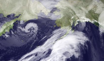
A heavy dose of rain and snow also was forecast for the northern tier of the West on Sunday night.

Temperatures have warmed to four degrees below zero in International Falls, Minnesota, up from 46 below zero on January 21, the coldest day in over 100 years, officials said Sunday.

There were no deaths or injuries related to the weather in the border town of about 6,000 people and weather is expected to slowly improve to 25 degrees Fahrenheit by Wednesday.

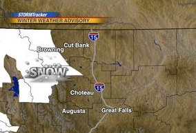
A storm front sweeping the Rockies was expected to bring gale-force winds and hurricane-strength gusts to the region, the National Weather Service reported in Great Falls, Montana.

High-wind warnings and travel advisories were posted for the Montana capital of Helena and the central part of the state, with hazardous conditions stretching from the Canadian border to the Wyoming line.

The storm was expected to push across Montana and into North Dakota by early Monday.